Posts in Category: technology
Hacking Historical Maps… or trying to
This weekend, I spent Sunday afternoon experimenting with solutions for historical mapping with Mia Ridge, a digital humanist and doyenne of hack days. We staged our own mini hack day to work through some of the challenges involved with the mapping side of my project on Parisian parishes, a major component of which involves geolocating demographic data to map the neighbourhoods in which artists lived in 18th-century Paris.
Over the past few years I’ve done the archival digging to come up with the data and now I’m at the stage of looking for the best ways to visualise it, both for research purposes (i.e. for me to use while thinking through and writing up the results) and for publication (i.e. how do you get copyright to publish a map in a book or journal article when you’ve built it on a commercial service like Google Maps?). Today we were mainly focusing on the first problem as it seemed the easier of the two, but ideally there’ll be a single solution for both.
I experimented with two websites, Georeferencer and Hypercities, both of which I’ve used in the past, but today I was hoping to explore some more of their features. In the end, however, while both have some useful functionalities, neither was perfectly suited to my requirements (though it must be said that Hypercities seemed to have a bug that was preventing data from being saved so it was difficult to explore far). As you can see from the screenshot of my results with Georeferencer, I successfully georeferenced a fragment of an 18th-century map on Google Maps… but there was no way to geolocate historical data on it.
Mia experimented with Metacarter and Mapwarper, and has written up her results and experiences over at Open Objects. I have a major problem with sites like Metacarter because everything you produce is publicly visible, which obviously makes it very difficult when you’re working with unpublished data. Most sites allow the option of keeping the maps you make restricted and that makes more sense for academics using these sites for research purposes. I’m excited to share my research when it’s complete, but I’d like to have control over what happens in the meantime.
| Administrative map of Paris, 1890 (Uni of Chicago Library) |
So all-in-all I didn’t discover the ideal open-access resource in a single afternoon (shock-horror) and for now I’ll just have to keep going with the methods I’ve been using. But I have been able to pinpoint more accurately what it is that I’m looking for and what challenges I face in finding it. And as a happy bi-product we also discovered lots of wonderful sites providing access to historical maps that I hadn’t encountered before, like the David Rumsey Map Collection and a great collection of 19th-century maps of Paris at the University of Chicago Library (most in high resolution with zoomify for getting into the detail of street level, as you can see in the screenshot).
Google Arting About: an art historian’s perspective on Google Art Project
 I got talking with some non-art historians one lunchtime this week about Google Art Project and its applications for art historical research. Most of them were quite surprised that I didn’t just think it was a silly toy for amateurs. But really, what’s not to like about making art history feel like play!?
For most people, visiting a museum (especially when overseas) is a tourist experience; for me, it’s usually work, but that doesn’t mean I don’t enjoy it. Research trips are fun but they are still research. So if Google Art is for the most part about giving people the chance to be ‘virtual tourists’, then I don’t see why it doesn’t give me the same chance to be a ‘virtual researcher’.

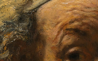 Not only is it great to be able to visit museum collections that I’ve never had the opportunity of visiting in the flesh, like the Hermitage, but also the resolution of the images makes it a really useful art viewer. There’s just no way you can get that level of detail (particularly brushwork) in most images on the internet (with a few exceptions like the National Gallery’s zoomy viewer). For me, the detail really is the highlight. Art historians are often interested in less obvious details than those that are usually photographed – Google Art means you can zoom on all kinds of weird things, take a screenshot, and throw it into a Powerpoint presentation for your next class or conference paper.
Another thing I was particularly excited about was not just ‘visiting’ galleries I’d never been to, but seeing old favourites in new ways… that is, in ways not possible when you’re standing in the room. I’ve been doing some work on François Lemoyne recently, so when I first had a play with Google Art I went straight to Versailles to hunt out the Apotheosis of Hercules that he painted on the ceiling of the Hercules Salon. I’ve spent many hours standing in that room being jostled by hundreds of tourists, straining my neck and nearly falling over backwards to try and see Lemoyne’s painting. And forget photographing it, that’s always a complete blurry and piecemeal disaster.
 But here it is on Google Art, in amazing high resolution that allows you to zoom in on the details in a way that would never be possible in real life… while also being situated in its original setting, so you don’t forget how it was supposed to be viewed and experienced. This way I’m able to consider not only its reception, but also its production: I get to experience how the courtiers saw it from the ground, but also to see it with the proximity that Lemoyne did from the scaffolding when he was painting it. (As an aside – the only problem with this at the moment is that only half the ceiling has been photographed… I’m hoping this will be amended in the fullness of time).

With the Versailles example, once again I can see how it’s going to become a really useful teaching and presentation tool. I can take a screen shot of the room and the floor plan, showing exactly where in the palace the painting is so I can show students and others who haven’t had the chance to see it in situ for themselves. How great will that be for teaching museum studies and curating courses, giving students a virtual experience of the space and the context of its location in the museum all at once? Of course, in this respect, one of the pros is also one of the cons… it may be an art historian’s relief to see the Mona Lisa without crowds of tourists, but it’s certainly not an authentic experience of the object from a museological perspective.
Google Art is not flawless and it’s not free of issues… but for the art historian, it’s fun, useful and exciting. And that’s enough for me.